


GPS area measure - land survey
GPS area measure - land survey介绍
Want to know the true size of your land?
Measure the perimeter of a field?
Determine the exact position of that border stone?
Collect GPX-data and visualize at home?
How to use:
Simply press the green button "GPS WALK" and start walking.
Now walk along the border of the area.
If there is any obstruction just press "PAUSE" and move on to the next accessible point.
Continue with "GPS WALK" or "GPS POINT HERE".
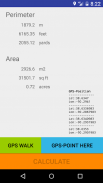
Once you are done click "CALCULATE" and the app will determine the area and perimeter.
The last position will automatically connect with the first position so you do not need to worry about closing the area exactly.
For convenience, area and perimeter are presented in imperial and metric units,
"m2", "acre", "squarefeet" for areas and "m", "feet" and "yards" for perimeters.
Now you can send the GPS-data via email to your (or other peoples) mail-account.
Cut the GPX-part and paste it into one of the many GPS-visualizers available on the Internet.
How it works:
The app strictly follows the WGS84-model to transfer Latitude- and Longitude-data to metric distances between waypoints.
WGS84 is currently the reference system being used by the Global Positioning System.
It originally used the GRS 80 reference ellipsoid, but has undergone some minor refinements in later editions since
its initial publication. WGS 84 uses the EGM96 (Earth Gravitational Model 1996) geoid, revised in 2004.
This geoid defines the nominal sea level surface by means of a spherical harmonics series of
degree 360 (which provides about 100 km latitudinal resolution near the Equator).
Permissions needed:
android.permission.ACCESS_FINE_LOCATION
android.permission.ACCESS_COARSE_LOCATION
android.permission.ACCESS_LOCATION_EXTRA_COMMANDS
android.permission.LOCATION_HARDWARE
this app will:
- measure acreage
- convert acres to square feet (internal)
- assists in land survey
- measure the total distance of your waypoints
- calculate perimeter
- area measurement
- fields area measure
- gps walk
想知道你的土地的真实大小?
测量领域的周长是多少?
确定边界石头的确切位置?
GPX收集的数据和在家里想象?
如何使用:
只需按下绿色按钮“GPS WALK”,并开始行走。
现在,沿区域的边界走。
如果有任何障碍物只要按下“暂停”并移动到下一个访问点。
与“GPS走”或“GPS点这里”继续。
一旦你完成点击“计算”和应用程序将确定的面积和周长。
最后一个位置会自动与第一位置连接,所以你不必担心正好关闭的区域。
为了方便起见,面积和周长的英制和公制单位给出,
“M2”,“亩”,“squarefeet”的区域和“M”,“脚”和“码”的周边。
现在,您可以通过电子邮件发送的GPS数据到你(或其他人)的邮件账户。
切GPX-部分并将其粘贴到互联网上提供的许多GPS,可视化工具之一。
怎么运行的:
该应用严格遵循WGS84模型到Latitude-和经度数据传输到路点之间的距离度量。
WGS84是目前正在使用的全球定位系统的参考系统。
它最初使用的GRS 80参考椭球,但已经发生了,因为在以后的版本一些细微的改进
首次出版。 WGS 84采用了EGM96(地球引力型号1996)大地水准面,2004年修订。
这个大地水准面通过的球面谐波一系列手段限定标称海平面表面
度360(其提供接近赤道100公里左右纬向分辨率)。
权限需要:
android.permission.ACCESS_FINE_LOCATION
android.permission.ACCESS_COARSE_LOCATION
android.permission.ACCESS_LOCATION_EXTRA_COMMANDS
android.permission.LOCATION_HARDWARE
这个程序将:
- 测量面积
- 转换亩平方英尺(内部)
- 协助土地调查
- 测量您的航点的总距离
- 计算周长
- 面积测量
- 字段区域措施
- 步行GPS
GPS area measure - land survey - 版本1.14
(26-02-2020)GPS area measure - land survey - APK信息
APK版本: 1.14程序包: com.sekora.deviceloc1GPS area measure - land survey的最新版本
其他版本


![勇闯死人谷 [Into the Dead]](https://cdn6.aptoide.com/imgs/3/4/d/34df5fe7fab8efc173a278bf1fcb4d73_fgraphic.png?w=404&h=228)
同类应用


